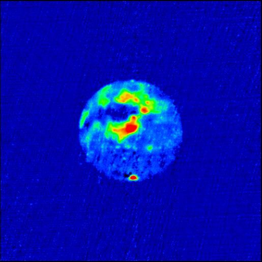
Radar Image of Mars
Description
This is a radar image of Mars, made with the Goldstone-VLA radar system in 1988. Red areas are areas of high radar reflectivity. The south polar ice cap, at the bottom of the image, is the area of highest reflectivity. The other areas of high reflectivity are associated with the giant shield volcanoes of the Tharsis ridge. The dark area to the West of the Tharsis ridge showed no detectable radar echoes. The investigators call this region the "Stealth" region and believe it is a huge deposit of low density, volcanic ash with an absence of volume scatterers (rocks) to depths of many meters.
The JPL/DSN Goldstone 70-meter antenna reflected a CW signal at a wavelength of 3.5 cm with 350 kW of power off the surface of Mars. The signal was received by VLA antennas in the A-array. This gave a resolution of 0.2", or 92 km on the surface of Mars at the sub-earth point. Image in "depolarized" mode (i.e. right circular polarization transmitted, and right circular polarization received).
Creator
Legacy Astronomical Images
Rights
NRAO/AUI/NSF does not hold full copyright for this image. Contact the archivist for details.
Type
Legacy Astronomical Image
Object Name
Mars
Investigators
D. Muhleman, B. Butler, A. Grossman, M. Slade
Telescope
Very Large Array (VLA)
Goldstone
Observation Date
1988-00-00
Type of Observation
continuum
Band
X
Wavelength
3.6 cm
Frequency
8.4 GHz
Center of Image
RA 25:0:0.000, Dec: 0:0:0.000 (J2000)
Series
Solar System Series
Unit
Planets Unit
Citation
Legacy Astronomical Images, “Radar Image of Mars,” NRAO/AUI Archives, accessed April 20, 2025, https://www.nrao.edu/archives/items/show/33608.

